


GR70_Le-Pont-De-Montvert-Florac

svp59
User
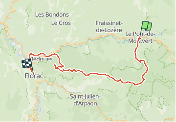

Length
29 km

Max alt
1421 m

Uphill gradient
833 m
Km-Effort
42 km

Min alt
537 m

Downhill gradient
1163 m
Boucle
No
Creation date :
2014-12-10 00:00:00.0
Updated on :
2014-12-10 00:00:00.0
8h30
Difficulty : Medium

FREE GPS app for hiking
 SityTrail
IGN / Geographical institutes
SityTrail Plus
The world is yours!
About
Trail Walking of 29 km to be discovered at Occitania, Lozère, Pont de Montvert - Sud Mont Lozère. This trail is proposed by svp59.
Positioning
Country:
France
Region :
Occitania
Department/Province :
Lozère
Municipality :
Pont de Montvert - Sud Mont Lozère
Location:
Le Pont-de-Montvert
Start:(Dec)
Start:(UTM)
559245 ; 4912482 (31T) N.
Comments